Version 3 due in June!

We have been busy, with both software and content development. Version 3 of the World Historical Gazetteer has been in development since February 2023, and a beta version will be available mid-2024. What follows is a brief outline of what we have been working on, much of which came as suggestions from our user community. Details will follow in the coming weeks and months, on this blog and on Twitter. We do expect to establish a Mastodon account soon as well.

Version 3 (alpha) home page

New “Gazetteer Builder” feature

  • Link multiple datasets in a single collection, e.g. for a group or individual to assemble a “Historical Gazetteer of {x}”
  • Merge multiple datasets into new dataset
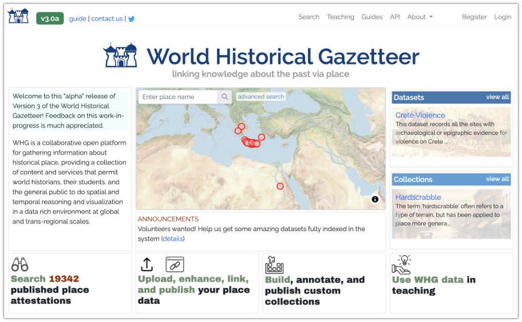
Home page

  • A map(!), with search and advanced search
  • ‘Carousels’ of published datasets and collections, with extents previewed on the map
  • Improved explanation of what the WHG offers
  • News and announcements

Maps

  • All 14 maps on the site significantly upgraded
  • Most maps now have temporal controls: a timespan ‘slider’ and/or a sequence ‘player’
  • Faster display of large datasets and collections, thanks to WHG’s own new “tileboss” server

Search

  • Search now across all published records-the confusing “search the index or database” choice is gone!
  • Options for ‘starts with”, “contains”, “similar to” (aka fuzzy) as well as ‘exact’
  • Spatial filter on search results
  • More information returned in search result items

Place Portal pages

  • Complete makeover of its design
  • Physical geographic context: ecoregions, watersheds, rivers, boundaries
  • Nearby places
  • Preview of annotated collections that include the place

Publication and editorial workflow

  • We are now especially highlighting three types of publications: Datasets, annotated Place Collections, and Dataset Collections
  • Expanded Managing Editor role
  • Improved tracking of contributors and data, from ‘interested’ to full accessioning
  • DOIs for data publications, enhanced metadata, significantly enhanced presentation pages
  • Improved download options

Annotated place collections for teaching

  • Support for class and workshop group scenarios
  • Optional image per annotation
  • Order places sequentially with or without dates
  • Enhanced display and temporal control options
  • Optional gallery per class
  • Site-wide student gallery

“My Data” dashboard and profile

  • Single page, simpler

Study Areas

  • Discontiguous areas, e.g. Iberian peninsula and S. America as a single area

API and data dumps

  • More endpoints, better documented
  • Regular dumps of published data in multiple formats

Codebase

  • Improved file upload validation and error reporting
  • The codebase is now “dockerized,” making it much easier to contribute to the platform’s development
  • Upgraded versions of all major components: Django, PostgreSQL, Elasticsearch, etc.
  • All map-related functions refactored for efficiency

Version 2 is here!

We are pleased to announce the release of Version 2 of World Historical Gazetteer! New features have been added, and we’ve made several significant improvements to usability.  This work was made possible by the continued support of our home institution, the World History Center at the University of Pittsburgh, and especially by the collaboration and support of the Humanities Cluster of KNAW.

In recent months we asked several contributors to pause their data preparation in the WHG system while these improvements were made. We can finally “re-open the doors” so to speak,  so we invite those efforts to resume, and again encourage new contributions and collaborations. We will respond quickly to any bug reports or general inquiries about using the platform.

Over the next several months we will be adding quite a bit more data that is already in the queue. Although much user interaction with the WHG platform is self-guided and semi-automated, we have found that contributions move most smoothly with staff support. WHG staff stand ready to help with data conversion strategies and with the planning of contributions generally. Please do get in touch with us (whg at pitt dot edu) or with any individual WHG project team members individually.

What’s New

The Site Guide and several tutorials on the WHG site describe its features and their use in some detail. The following briefly summarizes what is new since Version 1.

Collections

Registered users can now create “collections,” linking sets of existing public datasets within the system for purposes of presentation and combined search. This new feature aims at supporting the development of “focus regions” within WHG by collaborative groups with overlapping region/period interests.

Revamped search

Previously, search capability was limited to records fully accessioned into the WHG “union index,” and returned sets of one or more “closely matched” attestations of a place. This kept from view public datasets that had not yet been indexed. An option to search all public data within the WHG database—indexed or not—has been added to give a more complete view of the data we hold.

Reconciliation review

We have adopted the term “linking” to refer to all tasks of reconciliation and alignment—to external the external sources Wikidata, Getty TGN held in our sytem and to our own WHG union index. All of these require a “Review” step, where the prospective matches discovered in the task are presented for closeMatch/no match/defer decisions. The progress of this process, which can sometimes extend over time and involve multiple people, is now tracked in the Dataset Browse screen available to the dataset contibutor (“owner”) and designated collaborators. The choice to “defer” is also new since v1.2; it permits maintaining a separate queue of records, allowing users to move quickly through the easier decisions and set aside those requiring more attention, or review by others.

Views and downloads of public data

We now provide summary descriptions and mapped browsing for all datasets, collections, and individual place records that have been flagged as public. Public datasets can now be downloaded, according to CC-BY-4.0 license terms.

Faster maps

We have implemented the MapLibreGL technology for our Dataset and Collection maps, dramatically enhancing the speed of rendering large numbers of features.

Local Wikidata index

Since Version 1.2 in May, we have maintained a local index of about 3.6 million Wikidata place records, making reconciliation tasks for that resource 3x faster than the earlier SPARQL queries over the web–processing about 150-180 records per minute.

More reliable upload validation

Accounting for every possible anomaly or error in upload files is tricky. We have significantly improved the validation algorithm, trapping more errors with more user-friendly responses.

Miscellaneous

Site documentation has been edited and extended, and a number of display problems were fixed. SSL protocol (https) has been implemented for secure transfer.